
The trailhead parking off SR 137 is difficult to spot coming in from Waterville. I parked at the Oakland town offices, which are located on the West side of the stream.
I visited the historic plaque marking CMP’s first hydroelectric power station and the origins of the company founded by Walter Wyman in 1899.

Penstocks and hydro plant seen here from the bridge above the dam.
I walked along the penstocks leading to the old (National Historic Register) & currently used hydro generation building. I walked down past the former Cascade Woolen Mill buildings before I realized that the trailhead must be on the East Side of the stream.
I crossed the bridge to the trail parking and

onto the trail with an informative kiosk with aerial photo map. The kiosk said that the trail was 2.5 miles to Rice Rips road. The K-M website lists the trail at 3 miles. After walking it, I agree with the 2.5 miles.
After going through a doorway in the fence, I entered the mature Hemlock forest of the Messalonskee Stream valley.

The mature trees and wide trail reminded me of walking trails in Europe. The red on white blaze also reminded me of European blazes[the blazes changed color later along the trail to blue on white and I am not sure why.]

IS THE TRAIL WIDENING TOO MUCH?

The first mile of trail involves a lot of sidehilling – apparently done by the MCC crew in 2006. On high traffic trails, there is a tendency for the compacted treadway to ‘drift downhill’ along sidehills. Walkers, when given the choice, will take the easiest route, which is often the downhill side. The outer edge of the sidehill bench is not as stable as the part nearest the hill and so hiker feet move the soil slightly downhill which widens the trail. Trail width was 6-8’ in places.

There are few understory plants. So the woods ‘look’ wide open. In denser woods, the dense trees and bushes keep the treadway pretty narrow – in fact, the trail corridor often has to be cut back to maintain a desired 3-4 foot clearance. Ways to keep the trail from drifting downhill or ‘widening’ are to encourage hikers through the use of stone and trees, to stay on the uphill side. When large diameter ‘blowdowns’ occur, only cut a narrow passage to better define the desired treadway. Overall, though I thought that the trail was in good shape given the high use.
WHY IS THERE A ‘SIDE TRAIL’ ALONG SIDE THE BOG- BRIDGING?
I presume that the bog-bridges or puncheon were installed to protect the boggy area and plants (from widening mud holes) rather than to keep hikers feet dry. However, if the ground is dry and given the choice, hikers will stay on a nice path rather than step up onto the bog-bridges.


You could install small signs to encourage bridge use to protect the fragile plants or make the social sidepath look uninviting with brush or obstacles (or do both).

Once out on the powerline, the hiking trail joins the ATV trail. New visitors, like me, could use some ‘reassurance’ that we were still on the trail. There were only a couple of signs and no blazes along this section.

The wooden penstocks with their patches and leaks are quite interesting. This is a large wooden pipe and quite old. It is impressive how it still works under all this pressure. I tried putting my finger to block one of the many water squirts (like the little Dutch boy and the dike) and found that the effort just sprayed water all over me.
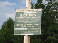
Again with no blazes or signs, there was no indication that a trail went any further to the East past Rice Rips road. This fishermen’s parking lot gave no indication that there was a trail across the street.
After completing the 5-mile round trip walk, I crossed the bridge back to my car by the town offices past bagpipers practicing in the park.

The wafting music in the valley made the trail experience seem even more European.
No comments:
Post a Comment